The Meanings Behind Hong Kong's Oldest Street Names
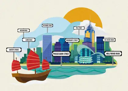
Since the colonial British government first raised their flag on the northern shore of Hong Kong Island in 1841, the city’s architecture, food, demographics, and lifestyle have all been met with a distinct British influence on the Chinese geography and identity.
The streets that we live and breathe on, the streets that we recognise instantly and can place on a map have a rich history, but many do not know the distinct history of the meanings of the roads, streets, lanes, and rows.
Read down further to see the true meaning behind some of the most famous streets that make up Hong Kong!
Nathan Road
Nathan Road is Kowloon’s main thoroughfare, a four-laned stretch of road measuring 3.6 kilometres aligning south-north from Tsim Sha Tsui to Sham Shui Po.
Today, running along Chungking Mansions, the Kowloon Mosque, Kowloon Park, and iSQUARE, the first section of the road was completed in 1861 in a bid to connect to the reclaimed land of south Kowloon and connect to business further north in then-colonial Hong Kong.
Nathan Road was the very first road built in Kowloon land that was ceded by the Qing dynasty Chinese government to the British government in 1860. Originally named Robinson Road, after Sir Hercules Robinson, Hong Kong’s 5th Governor, the road was changed to Nathan Road in 1909, after Sir Matthew Nathan, the 13th Governor who served between 1904 and 1907.
Pottinger Street
Pottinger Street, also known as Stone Slabs Street in Chinese, named after the unevenly paved granite stone stepped street, is of Hong Kong’s most famous stretches of road, leading from Queen’s Road Central to Wyndham Street.
One of the city’s earliest built streets, the patch was named in 1858 after Henry Pottinger, the first Governor of Hong Kong who served his role from 1843 to 1844.
The city’s first Roman Catholic cathedral of Hong Kong was built in 1843 on the corner of Pottinger Street and Wellington Street, which, along with the street, acted as a boundary between the Chinese and European residents of the area.

Peel Street
Known today as the go-to spot of a la carte dining and street boozing, the 560-metre-long Peel Street is a small street that begins from Queen’s Road Central and reaches up the hill into the Mid-Levels.
The road was built in 1840, when the first British colonisers arrived on the Hong Kong shores, to allow for travel from the harbour-side fishery industry to the colonial quarters.
Peel Street was named in late 1841 after Sir Robert Peel, former -Prime Minister of the United Kingdom from 1841 to 1846. Initially an area settled by European traders, Chinese locals occupied the area from the 1870s, with the expatriates migrating to the Mid-Levels.
Queen’s Road
Queen’s Road is Hong Kong’s first road, constructed by the British Royal Engineers between 1841 and 1843. The street ran parallel to the harbourside beach, where Sir Henry Pottinger first set up his tent in 1842 once the land of Victoria was ceded by the Qing dynasty government to the colonial British government.
The street was named Queen’s Road in March 1842, previously Main Street, after Queen Victoria of the then-ruling British Empire. In the early days of Hong Kong as a British Crown Colony, Queen’s Road was a hub for the island’s activity: new immigrants would first come to the arterial road, trade offices and business were built, and life in the city started on Queen’s Road.

Caine Road
Caine Road, built in early 1859, is Mid-Levels' largest roads running from the west of Bonham Road and ending at Government Hill in Admiralty. The road is named after William Caine, the acting Governor of Hong Kong, only in power from May till September of 1859.
During the American Civil War from 1862 to 1865, Caine Road was home to Sara Roosevelt, the mother of former-President of the United States, Franklin D. Roosevelt. Their family had a permanent residence at Rose Hill on Caine Road in the 19th century.
Boundary Street
Boundary Street in Kowloon previously marked the boundary between the southern part of Kowloon, ceded by the Chinese government to Britain in 1860, and the northern part of Kowloon leased to the United Kingdom in 1898 for 99 years.
The original border boundary stood as a long line of high bamboo fencing that was constructed to impede any illegal smuggling at the time. It was only until 1934 that the street took shape with concrete, built to accelerate development of Kowloon Tong.
Hollywood Road
Hollywood Road is the second road to be built in Hong Kong, following Queen’s Road Central, during early colonisation of the island. The origins of its name remain somewhat mysterious.
Historians suggest that the street was named after the family home of Sir John Francis Davis, the second Governor of Hong Kong; others suggest that the street got its name from the indigenous holly shrubs growing in the area when the road was constructed in 1860.

Des Veoux Road
One of Hong Kong Island’s most well-known roads, Des Veoux Road finds its name after the 10th Governor of Hong Kong, Sir William Des Veoux, who oversaw the ruling of the island from 1887 to 1891.
The complete construction of the road took 47 years, accounting for plans of the Praya Reclamation Scheme, which saw commercial work in land reclamation in the mainly Chinese dominant Western District to expand the harbour praya, and Des Veoux Road.
Possession Street
One of Hong Kong’s most important colonial points and British-created streets, Possession Street stands where the British once claimed possession of Hong Kong in 1841.
On Jan. 20 1841, British forces met with officials of the Qing dynasty to agree to the takeover control of Hong Kong Island. Surveyors with the British army found an elevated plain of ground near the small natural harbour for camping west of the island.
A small road was built from the shore to the camp, later becoming Possession Street. Six days later, the commander of Far East Fleet, James John Gordon Bremer, arrived in Hong Kong to mark the official possession of Hong Kong at today’s Possession Street.

Subscribe to The Beat's newsletter to receive compelling, curated content straight to your inbox! You can also create an account with us for free to start bookmarking articles for later reading.


